|
4-April-2008 FEP-EVV-PDK-MEI-AEX-CLL-SAT-MEI-AEX-PDK-?-FEP
|
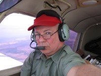
N7857N: |
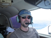
N5712F: |
|
The westbound trip took 4 legs and 9 hours flying time in 11 hours elapsed
time. We were not on the ground long for our stops. Ryan was under the hood
nearly the whole time. On Friday 4/11 about noon we began the long trip back to
KPDK. We were heavy, the day was hot, and ATC wanted us to expedite our climb.
Ryan was now flight planning, filing, picking up clearances, running the radios
and…..oh, yes, flying the airplane. After the third time ATC asked Ryan for the
best rate of climb, and Ryan calmly replied he was giving best rate…..the Old
Dog here just couldn’t stand it any longer. The conversation went something like
this:
|
| 
|
|
SAT APPROACH: “Five Seven One Two Fox…….I need your best rate of climb!
|
|
N5712F: We're a little cherokee ... Roger, best climd.
|
|
N5712F: (Old Dog voice from right seat of N5712F) “One Two Fox here………it’s hot,
we’re heavy……and we’re giving you everything we got”
|
|
SAT APP: (significant change in tone)”Oh…..ah,.…roger, one two Foxtrot, ah……sir,
could you turn right to one eight zero…….I have traffic climbing out of Randolph
(air force base).”
|
|
N5712F: (still the old dog)” Roger One Two Fox is turning right to one eight
zero for traffic.”
|
|
SAT APP: “Thank you sir………”
|
|
So…..we were vectored around the back side (south side) of Randolph so ATC could
get the jet traffic out in a normal climb. I could see what was happening from
my seat on the right side. Ryan was under the hood. 18 minutes after takeoff we
finally reached our cruise altitude of 7000 feet.
|
|
We were following a cold front eastbound. It was the large storm system that
caused those tornados and severe storms in Kentucky and Tennessee. We had a
significant tailwind and reached Alexandria, LA (KAEX) on our first leg. From my
vantage point I could see the back side of the cold front even as we approached
KAEX. With a fresh load of gas, Ryan filed, picked up his clearance and we
departed KAEX headed for Greenwood, MS (KGRW). We were parallel to the cold
front tracking up to Monroe, LA, thence to Greenville, MS then straight east
into Greenwood. North of Monroe I called Lockheed Martin FSS to check on the
weather. We had good news, the METARS for Columbus, MS (KGTR) were up. Our back
up plan had been to get another 100 miles behind us if the weather would permit.
With the good news from FSS, Ryan amended the flight plan to KGTR. ATC promptly
gave us a GPS direct to GRW which left only 100 miles to go to Columbus Golden
Triangle Airport (KGTR) where we arrived after being airborne for 2 hours. At
one point our GPS speed was 141 kts.
|
|
|
We fueled and asked the local line service for advice on hotels and restaurants.
He not only gave us advice, he gave us the crew car to get into town as two
crews had just returned from dinner and no more were expected. We got to the
Holiday Inn, but no one was manning the front desk. From my strategic point in
the lobby, I could see Ryan at the front desk, and the local dogs lapping cool
fsaid at the bar. I motioned to Ryan to leave the bags at the desk and follow me.
Before he caught up to me I had two cold ones sitting on the bar waiting for us
as we debriefed the day’s trip. We could see the front desk from our stools, and
calmly waited out the desk clerk while slaking our throats.
|
|
Later, we slipped across the street to Chili’s for a low carb dinner and more
juice. By the time we were waiving good bye to Miss Mississippi and her friend
sitting next to her, today was beginning to turn into tomorrow. We resolved to
get up early and get a fast start on the day. Did i mention that they called last call...
|
Some resolve……..about 11:00 a.m. we were at the local Waffle House doing greasy
eggs, bacon and hash browns. Not to worry, the NOON BALLOON (my new name for
N5712F) would be off the ground by the time of it’s namesake.
The Peach Dog had already filed, picked up the clearance and departed before we
had lost our headache from the night before. Off we went for KPDK.
It was a cool, smooth, and fast ride. At one point we were showing 151 kts on
the GPS!!! Without much chitter chatter, Atlanta approach vectored us for the
ILS 20L approach at PDK. Ryan took the hat off about ¾ mile out on final for a
great crosswind landing. |
|
 |
|
However……..there was no time to dawdle, or congratulate ourselves, as the cell
phone was ringing and Mrs. Kathryn Funk as on the line. She announced she was
taxing in off the active at KATL (Hartsfield) and would we be on time to pick
her up????
|
|
Ryan: “But of course my dear……see you in 30 minutes”
|
|
We cleared our throats of the dust and roared off in the Black Funk Murano to
rescue Mrs. Funk. We came around the corner at the big airport to see a strike
three blonde standing there with her bag…….oh, I mean Kathryn standing there
with her bag.
|
|
Now we were thirsty……………the consensus was to repair to the north back to KPDK
and attend the restaurant of fame, the Downwind.
|
|
Karl spotted us at the door and just turned to grab a pitcher of beer. He
motioned to go out onto the deck to watch airplanes and promised the pitcher
would follow shortly. It and several more did find their way to our table. Later
we ate some dead fish, then, retreated to the Funk Estate for bed time.
|
|
Sunday morning arrived blue, bright and beautiful at KPDK. I was airborne at
7:50 CDT (12:50Z) in Cherokee N7857N knowing I had my work cut out for me as I
got up into the Ohio River Valley. By the time I was east of Nashville I was
vectoring around rain and snow showers. They gradually increased in frequency
and intensity until I finally gave up at Madisonville, KY to replace 3 hours of
gas and regroup vis a vis the weather. After 1 hour of contemplation I
determined that some action was better than no action and set off for Paducah,
KY. 5 minutes later the plan was amended to try and at least get 40 miles north
to Evansville, IN. As I got up in the area I could pick up the Carmi, IL AWOS
which claimed acceptable conditions. As I approach Carmi, the bottom fell out
and they went to 700 feet and 1 ½ miles in heavy rain. Not to worry, as I was
already getting Fairfield, IL which had acceptable conditions. And so…..I picked
my way north by northwest toward home. After an hour or so I got on the cell
phone (with the David Clark X10 headsets) to Ryan back at Funk FSS. Ryan gave me
metar updates and counseled that a route west of Decatur and Bloomington was the
best plan. I picked my way past Decatur and east of Lincoln and pretty much came
out in the clear after 3 hours of flying in continuous rain. I could see
Bloomington getting hammered by a 40 mile by 60 mile cell off to the east. I
bounced my way up to KFEP and landed 6 flying hours and 7 elapsed hours after
departing KPDK.
|
|
For the accountants and engineers, here are the statistics for this adventure:
|
|
Ryan Funk/N5712F: Total flying time Atlanta, San Antonio, Atlanta - 18 hours
- Hood time 17.5 hours
|
|
Mickel/N7857N/N5712F: Total Flying time Freeport, Atlanta, San Antonio, Atlanta,
Freeport - 29.5 hours
|
|
I stopped at the Club Headquarters, picked up a box of juice, went home to
Scioto Mills, sat down in front of the fire and talked to myself for awhile. Not
too much later I was counting Cherokees in my dreams.
|